Miles & Miles of Miles
the smooth way to rough it
Following is a description of what has become known as my "vacation" — a period of retrospective... a time to pause and reflect... to take stock of who I am and what I stand for, but mostly just to wander around aimlessly in the middle of nowhere, drinking beer and taking pictures. Southeastern Utah represents an area that I find irresistible — wide open views, no noise, no people... but one I missed out on seeing during my vacation last year.
I chose the month of March for this endeavor so that it would (supposedly) be after the unpredictable winter weather but before the hordes of German tourists showed up, with their annoying habit of following you everywhere and stopping whenever you stop, assuming that it was a "scenic photo spot", rather than, in many cases, just an opportunity for me to take a leak. At one point in my vacation last year I went so far as to pull off on some un-remarkable turnout, then set the camera and tripod up, pointing at absolutely nothing. Inevitably, within minutes a shiny new rental car clone of mine (or two) would screech to a stop behind me, disgorging a group of disbelieving but nonetheless determined point-and-shooters, scratching their heads as they perused the guidebook for whatever "feature" was hidden from them in the distance.
The focus of the trip would be to more or less wake up every morning and, depending on either the weather (99%) or my mood (1%), figure out where I would go and what I would do. Since my skills at setting up a schedule (and actually adhering to it) are almost non-existent, the idea of not having a schedule in the first place is rather appealing. There is a lot of open space in southern Utah and northern Arizona and hopefully my sporty little rental car would allow me access to a big chunk of it, as long as it didn't rain or snow, which it did...
The early morning shuttle flight from Redding, CA to San Francisco went off without a hitch, and even though my connecting flight to Las Vegas naturally left from the opposite side of the airport I made it in plenty of time (i.e. 10 minutes). After an uneventful crossing of the Sierra (a bit of turbulence here last year wreaked havoc with my in-flight beverage) I was deposited in the bowels of McCarran International Airport, where I could almost feel my body being penetrated with thousands of doses of radiation from the cellphone-toting hordes.
Arriving at the rental car pickup at 10:30 am, I crammed myself into an extremely new Dodge Stratus (781 miles on the odometer) and, after spending several minutes trying to figure out how to adjust things so that if my legs were comfortably extended toward the pedals I would still be in sight of the steering wheel, I roared away toward I-15, through the unreal world that surrounds the Strip. After driving a stick shift truck for years, I inadvertently surprised various drivers behind me when, after accelerating up an onramp into the 75 mph traffic on the freeway, I would mistakenly stomp on the brake pedal (thinking it was the clutch) in a futile attempt to "shift gears". This little tactic must have earned me the respect and admiration of my fellow drivers, since many of them, while zooming past me, honked their horns in appreciation and appeared to give me a hand signal that could only have meant "You Numbah One!"
After an hour or so of average desert scenery northbound on I-15, punctuated only briefly by the intriguingly-named Virgin River Gorge, my first stop was to be Oasis Discount Liquors in Mesquite, NV — the last outpost of "civilization" (and real beer) before venturing into Mormon Land. The first three items of the "10 Essentials", so well-known to Adventurers on every continent, were procured here — a styrofoam ice chest, two bags of crushed ice, and 3 six-packs of Guinness Extra Stout, along with sundry other condiments. Heading north again, and losing an hour switching to Mountain Time, I passed St. George and turned off the freeway toward Hurricane, UT. Wishing to avoid the $20 fee for driving through Zion National Park (which I saw last year) I headed southeast toward Freedonia, AZ.
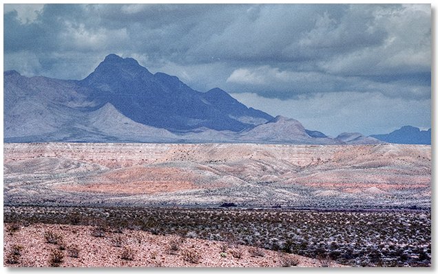
This stretch of highway began to develop "scenery", but it had rained recently and any dirt roads I passed leading out in the middle of nowhere were too muddy for my rental car, so I sped on toward Freedonia. Arriving there in the late afternoon and musing to myself that it would be a good location for filming a documentary about the history of trailer trash and/or abandoned vehicles, I turned north and crossed over into Utah, settling down for the night in Kanab at the extremely comfortable and inexpensive Parry Lodge. After dropping off a pile of my junk in the motel room I drove north on Highway 89 and poked around Coral Pink Sand Dunes State Park, where the sand, though not really a true "pink" because of the rain, had a very peculiar color and was as fine as flour. Watching the sunset from here was very cool, and the silence was deafening. Tomorrow I hoped to explore the Grand Staircase-Escalante National Monument but right now I needed some sleep.
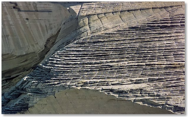
My appetite for crawling around on interesting rock formations had been whetted yesterday while driving past the southern end of Zion National Park so today, fueled by a large (and extremely HOT) cup of coffee, I embarked from my room at 9:00 am for an "exploring" day. Heading east on Highway 89 I drove up into Grand Staircase-Escalante National Monument on the Johnson Canyon road, one of the few paved roads in the area. Actually, the un-paved roads were fine — wide and well graded, but I could see (by deep ruts here and there) that once they got wet it would be a different story. The air was delicious and filled with the smell of sage and juniper, but the weather started to deteriorate so I drove back down to the main highway and headed east for another 30 miles or so, where I found another road the went up into the monument. This was a wide, smooth and DRY dirt road, so I drove a few miles off the highway and parked, then just wandered around, looking at this and that.
After an hour or so of shuffling around looking down at the ground for interesting rocks, etc. I stumbled (literally) into a rock where someone with the initials "J.H.B." carved the date "Jan. 1, 1914". This part of the monument still allows cattle grazing (ugh!) and I was prevented from exploring an interesting little box canyon by a small (but determined looking) herd of range cattle, who had staked out their "turf" and didn't appear to be too friendly. Bidding them adieu, I continued my wanderings through sagebrush flats punctuated with the occasional yucca plant. Further "punctuation" was provided by numerous prickly pear cacti, an aptly-named feature of this area that had just began to bloom here and there. What little firm crust left on the surface of the dry streambeds was lost to the hooves of the nomadic cattle, but the brush was sparse enough to allow reasonably effortless cross-country travel. Raptors were common everywhere I went, but I didn't notice any rabbits or rodents, and only a few deer. Eventually growing tired of zig-zagging around the countless sage bushes, I left and drove back toward Kanab and checked out Kanab Canyon for an hour or so before flopping down back at the hotel.
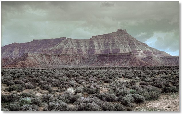
Today was a designated "driving" day, so after another nuclear cup of coffee from the corner espresso joint I began heading east on Highway 89 at 9:00 am. The landscape to the south of the highway was mostly flat, extending for about 75 miles out to the north rim of the Grand Canyon. To the north was a row of cliffs that paralleled my route for over an hour, every so often dipping down to reveal another row behind them and sometimes another in the distance, which, by their color, I recognized as being in Bryce Canyon National Park. Getting my first glimpse of Lake Powell near Page, AZ at 10:30 am, I felt an irresistible urge to stop for a "refreshment" when I saw a building with "Fred's Liquor Store" on the front — what are the odds?
Continuing east, this time on AZ 98, I made it to Kayenta a couple of hours later, where I got a room at the Wetherill Inn and set up camp. The plan was to check out some Indian ruins in Navajo National Monument this afternoon and then tomorrow drive up to Monument Valley Navajo Tribal Park, Goosenecks (of the San Juan) State Reserve and Valley of the Gods. As might be expected, afternoon thunderstorm buildup canceled the sidetrip to the ruins, so I relaxed in the motel pool and watched TV — how depressing! Kayenta, while certainly not a "destination" city, did have something going for it — as soon as you drove a few miles out of town you were "out of town" — no suburbs and endless strip malls here!
This whole area falls under the heading of "high desert" — I've been between 6,000 and 7,000 feet elevation all day and it became quite evident every time I'd bail out of the car and try to scramble up an embankment to get a photo. As everyone who visits the desert soon realizes, scale and distance are exaggerated, and every detail and feature is somehow reduced to earth and sky. The Navajo influence is everywhere (as it should be) and hitting a radio station in the Navajo language while channel surfing during the drive was a real "ear opener" — sort of like a monotonic, unisyllabic version of Spanish.
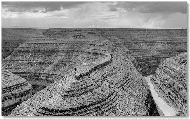
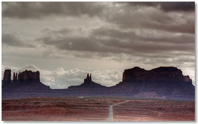
An old friend of mine who lives in Colorado drove over and met me last night and our plan to drive somewhere and go hiking today got off to a late start due to a bit of over-indulgence during our "reminiscing" period in the motel room — I'm glad I packed some aspirin! By mid-morning we finally hit the road, taking separate cars north on Highway 163 through Monument Valley Navajo Tribal Park and up to Mexican Hat, UT — quite possibly the smallest town I've ever been in. Missing a hearty lunch at the local Taco Bell because the owner "wasn't up yet", we grabbed a few candy bars, left my rental car in "town" and drove to the overlook at Goosenecks of the San Juan State Reserve.
The word "overlook" is not used lightly here (see photo above) and if someone wanted to launch a boat in the river they could possibly do it right from the parking lot — just push it over the edge and a few moments later (unless it was a windy day) it'd be in the river all right.
Even though the sky was about as threatening as it could be, and ignoring ubiquitous warnings about hiking in gullies and draws during rainy weather, we finally succumbed to the urge to wander and took off across the plain. A mile or so later we came upon a stone hut and continued to meander around as the coal-black sky closed in around us. We watched the ongoing progress of a snowstorm on the upper section of a nearby row of cliffs as the reddish rock turned to white and waterfalls materialized for a few moments and then disappeared, reappearing again with the ebb and flow of the storm. While being an observer of severe weather was indeed fascinating, we began to feel that soon we would become an integral part of the deluge if we didn't make tracks back to the car, so plans were made to return in the future for an extended visit.
Returning to the hamlet of Mexican Hat, we went our separate ways. As I headed back to the motel I wished the rain would go away so I wouldn't have to face another night of moronic TV shows, but such was not the case. Well, there's always tomorrow...
Walking toward the motel room window with trepidation upon arising, I dearly hoped that it wasn't raining. Well, it wasn't — it was SNOWING! I'm 400 miles away from where I need to return the rental car tomorrow and my last day for exploring and it has to snow — Rats! Realizing that I wasn't in a 4-wheel drive truck anymore and having absolutely no desire (or opportunity) to wait out the storm I hurriedly packed up and checked out of the motel.
The drive back was a nail-biter for sure. Even though there was only a few inches of snow on the roadway, my car only had a few inches more of ground clearance. What made it really exciting was the tracks made by the few vehicles that had passed by previously were from full-size pickups or semi trucks and were wider than the "intermediate" sized car I was driving, which made for a slalom-like ride. If you think desert scenery is boring and monotonous you should see it with any interesting features in the distance obscured by clouds and all of the nearby rocks, sand and shrubs covered by snow, permeated by the feeling of utter helplessness from the possibility of breaking down or going off the road in the middle of nowhere. These topics aside, it was a very relaxing drive once I passed the 6,750 foot high Marsh Pass and basked in the glow of knowing that it was pretty much all downhill from here.
The descent to Lake Powell reminded me of the beginning of the movie The Wizard of Oz, when everything changes from black & white into color. After driving in essentially "black & white" for hours in the snow and fog I suddenly dropped down under the clouds and was in "color" again — it had only rained at this elevation and the clouds were high enough to allow long views into the distance, which is where I was heading to get away from the crappy weather.
After leaving Kayenta at 7:30 am I made it back to Glendale, NV a little after 1:00 pm, thanks in part to rain instead of snow, a car equipped with cruise-control, lucrative speed limits and a burning, almost overpowering, desire to consume numerous beers. I got a room in the motel in town, then drove a few miles out to the Union Pacific mainline, which runs between Los Angeles and Salt Lake City, for a little "R & R". After the horrendous drive I couldn't bring myself to spend the night in Las Vegas, which was a mercifully short 40 miles away. Eventually my luck ran out and just before sunset a thunderstorm with lightning and pea-sized hail forced me to retreat to the car, but I was less than an hour from Vegas, and there were lots of trains and lots of beers...
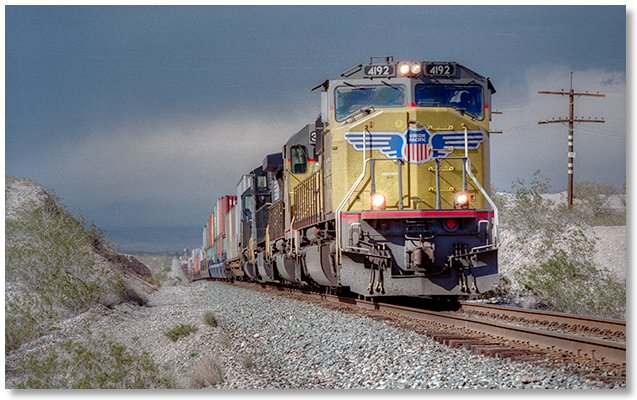
Today, in comparison, was uneventful. I had a good sleep on a surprisingly firm mattress and a good breakfast at the café next door, then packed up and headed for Vegas, stopping only briefly to watch trains. After a few hours of "seeing the sights" I resigned myself to returning the rental car and taking the shuttle out to the airport. My flight wasn't until almost 6:00 pm but somehow, after spending the last several days traveling around in the desert, I preferred the relative isolation of the departure terminal to the crowded casinos on the Strip.
Next year, I vowed, I'd wait until April to go anywhere, which foretells a warm and mild March, I'm sure.